


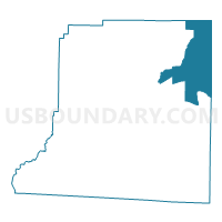
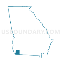
0871646 - PARKER Voting District, Decatur County, Georgia
About
Outline

Summary
| Unique Area Identifier | 561066 |
| Name | 0871646 - PARKER Voting District |
| County | Decatur County |
| State | Georgia |
| Area (square miles) | 47.60 |
| Land Area (square miles) | 47.04 |
| Water Area (square miles) | 0.55 |
| % of Land Area | 98.84 |
| % of Water Area | 1.16 |
| Latitude of the Internal Point | 30.99956130 |
| Longtitude of the Internal Point | -84.41246310 |
Maps

Graphs
Select a template below for downloading or customizing gragh for 0871646 - PARKER Voting District, Decatur County, Georgia


Neighbors
Neighoring Voting District (by Name) Neighboring Voting District on the Map
- 0871277 - BELCHER Voting District, Decatur County, GA
- 0871361 - CLIMAX Voting District, Decatur County, GA
- 087514 - BDGE-FAIRGROUND Voting District, Decatur County, GA
- 131L - LIMESINK Voting District, Grady County, GA
- 131SH - SPRING HILL Voting District, Grady County, GA
- 131W - WHIGHAM Voting District, Grady County, GA
- 205BV - BRANCHVILLE Voting District, Mitchell County, GA
- 205HF - HOPEFUL Voting District, Mitchell County, GA
Top 10 Neighboring County Subdivision (by Population) Neighboring County Subdivision on the Map
- Whigham CCD, Grady County, GA (2,702)
- Climax CCD, Decatur County, GA (1,847)
- Mount Pleasant CCD, Decatur County, GA (1,566)
- Branchville CCD, Mitchell County, GA (1,116)
- Northwest Grady CCD, Grady County, GA (551)
Top 10 Neighboring Unified School District (by Population) Neighboring Unified School District on the Map
- Decatur County School District, GA (27,842)
- Grady County School District, GA (25,011)
- Mitchell County School District, GA (19,600)
Top 10 Neighboring State Legislative District Lower Chamber (by Population) Neighboring State Legislative District Lower Chamber on the Map
Top 10 Neighboring State Legislative District Upper Chamber (by Population) Neighboring State Legislative District Upper Chamber on the Map
Top 10 Neighboring 111th Congressional District (by Population) Neighboring 111th Congressional District on the Map
Top 10 Neighboring Census Tract (by Population) Neighboring Census Tract on the Map
- Census Tract 905, Mitchell County, GA (6,084)
- Census Tract 9701, Decatur County, GA (3,413)
- Census Tract 9502, Grady County, GA (2,702)
- Census Tract 9501, Grady County, GA (2,297)